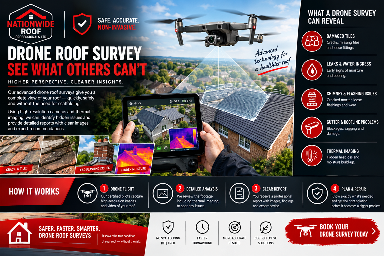
Quick answer: A drone roof survey uses a camera-equipped drone to capture close, high resolution images of an entire roof without anyone climbing onto it. It reveals cracked or missing tiles, damaged flashing, blocked guttering, and, with thermal imaging, trapped moisture. It cannot assess the roof void or timbers directly, so it is often paired with an internal loft inspection.
Traditional roof inspections rely on ladders, scaffolding, or someone walking across tiles that were never designed to be walked on. A drone roof survey removes that risk entirely while capturing images sharp enough to spot a hairline crack from ground level. It has quickly become one of the most requested inspection methods for UK homeowners dealing with insurance claims, pre purchase surveys, or simply wanting to know the true condition of their roof before committing to repairs.
This guide explains exactly what a drone roof survey involves, what it can and cannot tell you, and when it makes sense to request one.
What Is a Drone Roof Survey?
A drone roof survey uses a remotely piloted aircraft fitted with a high resolution camera to capture detailed images and video of a roof from multiple angles, without anyone needing to physically access the roof surface. The operator controls the drone from the ground, flying a controlled pattern over the property to photograph every elevation, valley, and junction.
The resulting images are reviewed by a qualified roofer or surveyor, who identifies defects, documents their location, and produces a report that can be used to support repair decisions, insurance claims, or mortgage requirements.
How the Process Works
Site Assessment
Before flying, the operator checks for obstructions such as overhead power lines, nearby trees, and airspace restrictions, since certain areas near airports or other sensitive sites require additional permissions before a drone can be flown legally.
The Flight
The drone is flown in a systematic pattern across the roof, typically starting with a wide overview pass before moving in closer to capture detail on specific areas. Most residential surveys take between fifteen and thirty minutes to complete, depending on roof size and complexity.
Image Capture
Modern survey drones capture still images at resolutions high enough to zoom in on individual tiles, mortar joints, and flashing details after the flight, rather than relying on real time viewing alone. Some surveys also include thermal imaging, which can reveal moisture trapped beneath roofing materials that is not visible in standard photography.
Reporting
The images are compiled into a written report, usually annotated with markers showing the location and nature of any defects found. This report becomes the reference document for planning repairs, supporting an insurance claim, or reassuring a mortgage lender or buyer.
What a Drone Roof Survey Can Reveal
A well conducted drone survey can identify a wide range of issues that are difficult or impossible to spot from ground level, including:
- Cracked, slipped, or missing tiles and slates
- Ponding water on flat roof sections
- Damaged or perished flashing around chimneys and roof junctions
- Blocked or damaged guttering and downpipes
- Moss and algae growth affecting tile integrity
- Cracked or displaced ridge and hip tiles
- Signs of previous repair work that may need revisiting
- General wear patterns that indicate how much useful life remains in the covering
Because the drone can capture images from angles a person on a ladder simply cannot reach safely, surveys often reveal defects on the far side of a roof or in valleys that have never been properly inspected before.
What a Drone Roof Survey Cannot Tell You
A drone survey is highly effective for visible external defects, but it has clear limitations. It cannot see beneath tiles, inside the roof void, or behind flashing, so it will not confirm the condition of roof timbers, insulation, or ventilation directly. It also cannot reliably assess structural strength purely from external images, since sagging or deflection often needs to be confirmed by physical inspection or measurement.
For a complete picture, particularly where structural concerns or spray foam insulation are involved, a drone survey is usually paired with an internal loft inspection. This combination gives both the external condition and the internal structure, which matters when a mortgage lender or surveyor requires full visibility of the roof timbers, a common requirement discussed in our spray foam removal blog.
Why Drone Surveys Are Becoming the Preferred Method
Safety
Roof access has historically been one of the most dangerous parts of property maintenance work. Removing the need for anyone to physically climb onto a roof eliminates fall risk entirely for the inspection stage, which matters both for the operator and for reducing liability for the homeowner.
Access to Difficult Areas
Steep pitches, tall properties, and roofs surrounded by conservatories or extensions can be genuinely difficult to inspect safely using a ladder. A drone reaches these areas without needing scaffolding or specialist access equipment, which also keeps costs down compared with erecting scaffold purely for an inspection.
Speed
A full drone survey of an average residential roof takes a fraction of the time required to erect access equipment and carry out a manual walk over inspection, meaning results are often available the same day.
Documentation Quality
Because every image is geotagged and timestamped, drone surveys produce a more thorough and defensible record than handwritten notes from a ground level visual check. This is particularly valuable for insurance claims, where clear before and after evidence can significantly speed up claim approval.
When Should You Request a Drone Roof Survey?
Before Buying a Property
A drone survey ahead of purchase can reveal roof condition issues that a standard visual survey might miss, giving buyers stronger negotiating position or advance warning of upcoming repair costs.
After Severe Weather
Storms, heavy snow, or high winds can dislodge tiles or damage flashing in ways that are not obvious from the ground. A prompt drone survey after severe weather provides clear evidence for any insurance claim and identifies problems before they lead to internal water damage, as covered in our storm roof damage checklist.
As Part of an Insurance Claim
Insurers increasingly accept drone survey evidence to support roof damage claims, since the detailed imagery removes ambiguity about the extent and cause of damage. This same evidence is invaluable for tracing an active roof leak back to its source without anyone needing to climb onto the roof.
Before a Roof Replacement
If you are considering a full re-roof, a drone survey gives an accurate picture of current condition across the entire roof, helping to scope the work properly before quotes are requested. This ties directly into the assessment stage described in our roof replacement guide.
Periodic Maintenance Checks
Even without a specific concern, a drone survey every few years provides an ongoing record of roof condition, making it easier to catch developing problems, such as early flashing wear or moss build up, before they become expensive repairs.
Drone Roof Surveys and Fascias, Soffits, and Guttering
A drone survey does not only capture the main roof covering. Because the flight path covers the entire roofline, it typically picks up the condition of fascias, soffits, and guttering at the same time, which is useful given how often problems in these areas go unnoticed from ground level. Our detailed guide to fascias and soffits explains what to look for if your drone survey report flags concerns in this area.
Drone Surveys Versus Traditional Roof Inspections
It helps to compare the two methods directly rather than assume one simply replaces the other.
A traditional inspection, carried out by someone physically on or near the roof, allows for tactile checks. A roofer can press on a tile to test for looseness, lift a flashing edge to check the seal underneath, or feel for soft spots on a flat roof membrane. None of this is possible with imagery alone, however detailed.
A drone survey, by contrast, offers complete coverage in a single visit, including areas that are genuinely unsafe or impractical to reach by ladder, such as steep valleys between two roof pitches or the far side of a roof that backs onto a boundary wall. It also produces a permanent visual record that can be reviewed later, compared against future surveys, or shared directly with an insurer or buyer’s surveyor without needing a second site visit.
In practice, many roofing professionals now use both methods together. A drone survey identifies where attention is needed, and a targeted physical inspection follows up only on the specific areas flagged, rather than requiring full scaffold access to check the entire roof by hand.
Thermal Imaging and Drone Roof Surveys
Some drone roof surveys include a thermal imaging pass alongside standard photography. Thermal cameras detect temperature differences across the roof surface, which can indicate moisture trapped beneath tiles or within a flat roof build up, since damp areas typically retain heat differently to dry materials around them.
This is particularly useful on flat roofs, where trapped moisture beneath the membrane is a common cause of long term deterioration but is completely invisible to a standard camera. Thermal imaging surveys are usually best carried out in the early morning or evening, when the temperature difference between wet and dry areas is at its most pronounced, giving a clearer thermal contrast in the resulting images.
Thermal surveys are not always necessary for every property, but they are worth requesting specifically if you suspect a leak that has not yet produced a visible internal stain, or if a flat roof section is due for renewal and you want to understand its current condition before committing to full replacement.
Interpreting Your Drone Survey Report
A good drone survey report does more than present a folder of photographs. It should organise images by roof elevation, clearly label any defects found, and provide a plain language explanation of what each issue means for the roof’s condition and expected remaining lifespan.
Look for a report that distinguishes between cosmetic issues, such as moss growth that affects appearance but not performance, and functional issues, such as cracked flashing that is actively allowing water ingress. This distinction matters when deciding what needs immediate attention and what can be monitored over time. A reputable provider will also be willing to talk through the findings directly rather than simply emailing a report and leaving you to interpret it alone.
Legal Requirements for Drone Roof Surveys in the UK
Commercial drone operators in the UK must hold the relevant Civil Aviation Authority operator ID and pilot competency certification, along with appropriate insurance for commercial flights. When arranging a drone survey, it is worth confirming that the operator holds these credentials, since flying without proper certification is a legal requirement, not simply best practice.
Homeowners do not need to do anything themselves to prepare for a compliant survey beyond ensuring reasonable access to the property and garden, since the operator handles airspace checks and flight planning as part of the service.
Frequently Asked Questions
How much does a drone roof survey cost compared with a traditional inspection?
Costs vary by provider and roof size, but drone surveys are often comparable to or less expensive than arranging scaffolding purely for a visual inspection, since access equipment is not required.
Can a drone roof survey be used for an insurance claim?
Yes. Most insurers accept clear, dated drone imagery as supporting evidence for roof damage claims, particularly when the report includes annotated images showing the specific defects being claimed for.
Does a drone survey replace the need for a full roof inspection?
Not entirely. A drone survey covers everything visible from outside the roof but does not assess the roof void, timbers, or insulation. For a full picture, it is often combined with an internal inspection.
How long does it take to receive the survey report?
Most reports are provided within a few days of the flight, though some providers can turn around straightforward surveys within twenty four hours.
Is a drone roof survey affected by weather conditions?
Yes. Surveys are typically rescheduled in high wind, heavy rain, or poor visibility, both for safety and because image quality is significantly reduced in bad weather.
Choosing a Drone Roof Survey Provider
Not every drone operator has roofing expertise, and image capture alone is only half the value of a survey. The images still need to be interpreted by someone who understands roofing defects, materials, and typical failure points. When choosing a provider, it is worth confirming that the report will be reviewed by a qualified roofer rather than simply handed over as raw footage.
It is also reasonable to ask what happens if the survey identifies a defect. A provider who only offers inspection services may leave you to source a separate contractor for repairs, adding delay and a second round of quoting. Choosing a company that offers both the survey and the repair work, where appropriate, tends to give a faster and more accountable route from identifying a problem to having it fixed.
Drone Roof Surveys Across London, Surrey and the South East
Urban terraces in London often have limited garden or street access for scaffolding and towers, making drone surveys a particularly practical option where traditional access equipment would need to close a pavement or reach permission from neighbours. Across Surrey and the wider South East, larger detached properties with steep or multi pitch roofs benefit from the drone’s ability to reach every elevation in one flight. Nationwide Roof Professionals carries out drone roof surveys for homeowners throughout these areas as part of our standard assessment process.
A Clearer Picture of Your Roof, Without the Risk
A drone roof survey gives homeowners something that was previously difficult to obtain safely and affordably: a complete, documented view of their entire roof from every angle. Whether you are dealing with storm damage, preparing for a sale, or simply want to know what condition your roof is really in, it removes the guesswork that comes with a quick look from the garden.
At Nationwide Roof Professionals, drone surveys form part of our wider roofing
services, giving you clear evidence before any repair recommendation is made. Request a free quote and we will talk you through whether a drone survey is the right starting point for your property.